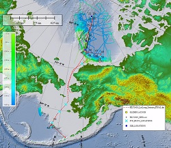
Arctic ECS Bathymetric Mapping
Vessel: USCGC Healy; Expedition Dates: September 17, 2016 to October 6, 2016; Ports: Nome, Alaska to Dutch Harbor, Alaska
Project Principals: Larry Mayer¹, Brian Calder²
Co-Project Principals: None
PI Institution(s): ¹University of New Hampshire
Partnerships: None
Grant #: Unknown; Award Period: Unknown

In the Arctic, September 18 - October 5, 2016 NOAA Ocean Exploration and the University of New Hampshire Center for Coastal and Ocean Mapping sponsored the 10th and very likely final U.S. ECS field survey aboard U.S. Coast Guard Cutter Healy. Survey priorities included the collection of dredge samples on Alpha Ridge and the collection of bathymetric data in the region north of the Alaskan north slope margin and on the Beringian margin, aimed at strengthening our understanding of our countries' continental shelf outer limits. Approximately 14,000 km2 of seafloor were mapped and 27 kg (60 lbs) of rock were collected and catalogued.
Project Datasets
| ADCP (Acoustic Doppler Current Profiler) - Hawaii UHDAS | Open |
| Geologic Samples | Open |
| GNSS (Global Navigation Satellite System) - MXMarine MX512 | Open |
| Gravimeter - Bell BGM-3 | Open |
| Gyrocompass - Sperry MK-27F | Open |
| INS (Inertial Navigation Systems) - Applanix POS/MV-320 V5 | Open |
| INS (Inertial Navigation Systems) - Kongsberg Seapath 330+ | Open |
| INS (Inertial Navigation Systems) - Kongsberg Seatex MRU-6 | Open |
| INS (Inertial Navigation Systems) - Sperry MK-39 | Open |
| Multibeam Sonar - Kongsberg EM122 | Open |
| Multibeam Sonar (centerbeam) - Kongsberg EM122 | Open |
| NCEI Multibeam: Kongsbers EM122 | Open |
| pCO2 (partial pressure of carbon dioxide) - LDEO pCO2 | Open |
| Singlebeam Sonar - Knudsen 3260 | Open |
| Speed Log - Sperry SRD-500 | Open |
| SSP (sound speed profiles) | Download |
| Trackline Data | Open |
| Winch - InterOcean 10628 (1) | Open |
| Winch - InterOcean 10628 (2) | Open |
| Winch - InterOcean 71217 (1) | Open |
| Winch - InterOcean 71217 (2) | Open |
| XBT (eXpendable bathythermograph data) | Download |
Processed Project Datasets
| Bathymetry - Singlebeam | Download |
Data Citation
| Mayer, Larry; Calder, Brian (2024). Environmental data and products from NOAA Ocean Exploration Funded Project: Arctic ECS Bathymetric Mapping. [indicate subset used]. NOAA National Centers for Environmental Information. Project Datasets. https://www.ncei.noaa.gov/waf/ocean-exploration-nofo/16HLY1603/16HLY1603_cruise_landing_page.html. Accessed [date]. |

